


Themed trail with audio guide: Rotmoostal - Obergurgl
Description
Obergurgl –> Hohe Mut Bahn ascent -> Hohe Mut –> Rotmoosferner stamp station –> Rotmoostal –> stone pine forest –> Obergurgl
Map & elevation profile
The Tour
Obergurgl –> Hohe Mut Bahn ascent -> Hohe Mut –> Rotmoosferner stamp station –> Rotmoostal –> stone pine forest –> Obergurgl
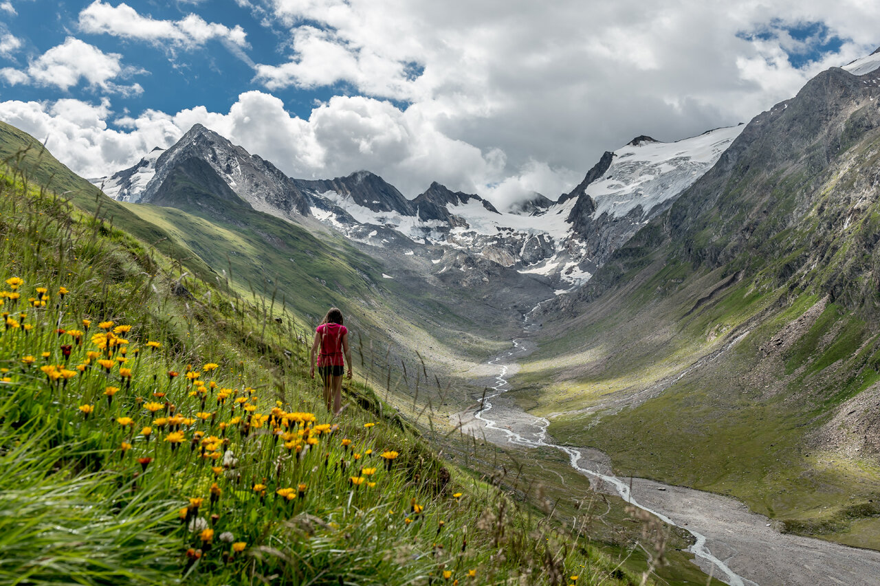
From the village square in Obergurgl, you walk comfortably to the valley station of the Hohe Mut Bahn. The discovery journey starts with a comfortable cable car ride. This allows the strenuous ascent altitude meters to be comfortably overcome. The route is also shortened to 12 km.
At the Hohe Mut saddle, we expect a magnificent panorama with views of more than twenty 3000 m peaks.
Once at the top, we walk comfortably on relatively flat and easy terrain towards Rotmoosferner. Then it continues on rough and rocky mountain paths to a striking moraine (2,720 m), the highest point of this hike. Arriving there, at the same time a stamp station, we stand directly in front of the mighty Rotmoosferner. Emerging from this impressive, pristine stone world, another historical archive opens up – the striking red Riedmoos of the Rotmoostal. The hike continues into the high mountain flower world at the managed Schönwieshütte. The adventure continues through the stone pine forest consisting partly of stone pines over 300 years old. In the middle is another highlight of this hike: the Rotmoos waterfall, which roars about 30 m over steep rocks carved into a dark gorge.
You follow the hiking trail past the stone pine alp, always back to the starting point in the center of Obergurgl.
The water walker Rotmoostal can also be walked as a circular route without using the Hohe Mut cable car. The hiking trail also starts at the valley station of the Hohe Mut cable car.
Themed trail without Hohe Mut cable car:
Distance: 14.8 km
Walking time: 6 h
Ascent altitude: 893 m
Regions & Places
Mountain areas
Details
Characteristics
Way types
Safety guidelines
Moderate mountain trail; suitable for sure-footed and experienced mountain hikers.
Good physical condition, mountain experience and mountain equipment (see under equipment) necessary. Please note the current weather report at: https://www.oetztal.com/en/summer.html
Additional information
Rotmoostal
- With a high content of sediments ("glacier flour"), glacier streams continuously plane and mill the stream bed.
- In meter-high peat layers, climatic conditions and past vegetation can be investigated, as this moor has developed over thousands of years since the last ice age.
WATER IN THE ÖTZTAL
Water, the defining element of the Ötztal.
The freshwater melted by the sun from the glaciers feeds the meadows and the Ötztaler Ache, which runs through the 65 km long valley. The catchment area of the Ötztaler Ache covers 893 km² with an altitude range between about 700 and 3,774 m. This glacier melt fills the population's water reservoir and ensures drinking water supply.
Glaciers store three quarters of all freshwater reserves and are thus the largest natural water storage facilities in the world.
In 1770, large lakes were repeatedly dammed by advancing ice, which caused catastrophic floods throughout the Ötztal and even in the Inn Valley when they broke. The natural hazard prompted people increasingly to engage with their environment and promoted glacier research. The diversity of water in the Ötztal also serves not only science. The Ötztal glaciers are also recreational areas for residents and guests, as these "ice wonders" additionally serve as hiking areas and mainly as ski areas. Moreover, glacier melt has made action-packed leisure activities such as rafting, white-water rafting, and many more possible.
More information about hiking in the Ötztal: https://www.oetztal.com/wandern
Directions
From Obergurgl on foot or by lift to Hohe Mut – to the highest point left of the lift station (location HM) – back to the hiking trail along the Mut ridge towards the glacier (southeast) – stop (location BH) at the so-called Bärenhoppet, where there is also a research hut of the University of Innsbruck – continuing towards the Rotmoosferner stamp station – stop at the Rotmoosferner stamp station (location SR) – descent along the Liebener ridge into the Rotmoostal – stop at the crossroads of the valley and hillside trail (location GR) – downhill towards Schönwieshütte – stop at the Rotmoos moor outside the glacier forefield (location RM) – continue past the reservoir along the access road through the Obergurgl ski area (location SG) or alternative return route to Obergurgl through the natural monument Obergurgl stone pine forest (trail).
Arrival
Public transit
Travel comfortably and safely by train to the Ötztal train station. The final stop or exit point is ÖTZTAL station. Afterwards, travel conveniently and quickly by public transport or local taxi companies through the entire valley to your desired destination! The current bus schedule is available at: http://fahrplan.vvt.at
Starting point
Getting there
The car journey to ÖTZTAL. Located in Tyrol, the Ötztal branches south as the longest side valley of the Eastern Alps. Arrival by car leads travelers over the Inn Valley to the valley entrance and further along the Ötztal. In addition to the toll motorway, local roads can also be used. Your route can be quickly and conveniently determined with the route planner: Route planner: https://www.google.at/maps.
Parking
The following parking options are available in Gurgl:
- Parking garage village center Obergurgl (down to the right in front of the church), paid | € 2.00 per hour
- Parking garage village entrance – Festkoglbahn valley station, paid | € 6.00 per day
- Parking lot Hochgurglbahn valley station, free – no night parking
- Parking lot Top Mountain Crosspoint, free
- Parking lot Hochgurgl, free (very small parking lot)
Current information
Midsummer-like hot
The tour is within these protected areas.
Equipment
Appropriate equipment such as breathable and weather-appropriate outdoor clothing, ankle-high hiking boots, wind, rain and sun protection, hat, possibly gloves, is required for all hikes and routes. It is necessary to bring a first aid kit, a mobile phone and possibly a hiking map, as well as sufficient provisions for hikes without the possibility of stopping for refreshments.