Winter Hiking recommended route

Winter hiking trail Rotes Wandl - No. 431

Winter Hiking · Oetz closed
Logo Ötztal
Responsible for this content
Ötztal Verified partner 
  • Photo: Ötztal Tourismus Büro Oetz, Ötztal

Selected alternatives for you

    PANORAMA RESTAURANT HOCHOETZ - Rotes Wandl - PANORAMA RESTAURANT HOCHOETZ

    closed
    easy
    Distance 1.5 km
    0:45 h
    52 m
    53 m
    2,012 m
    1,959 m

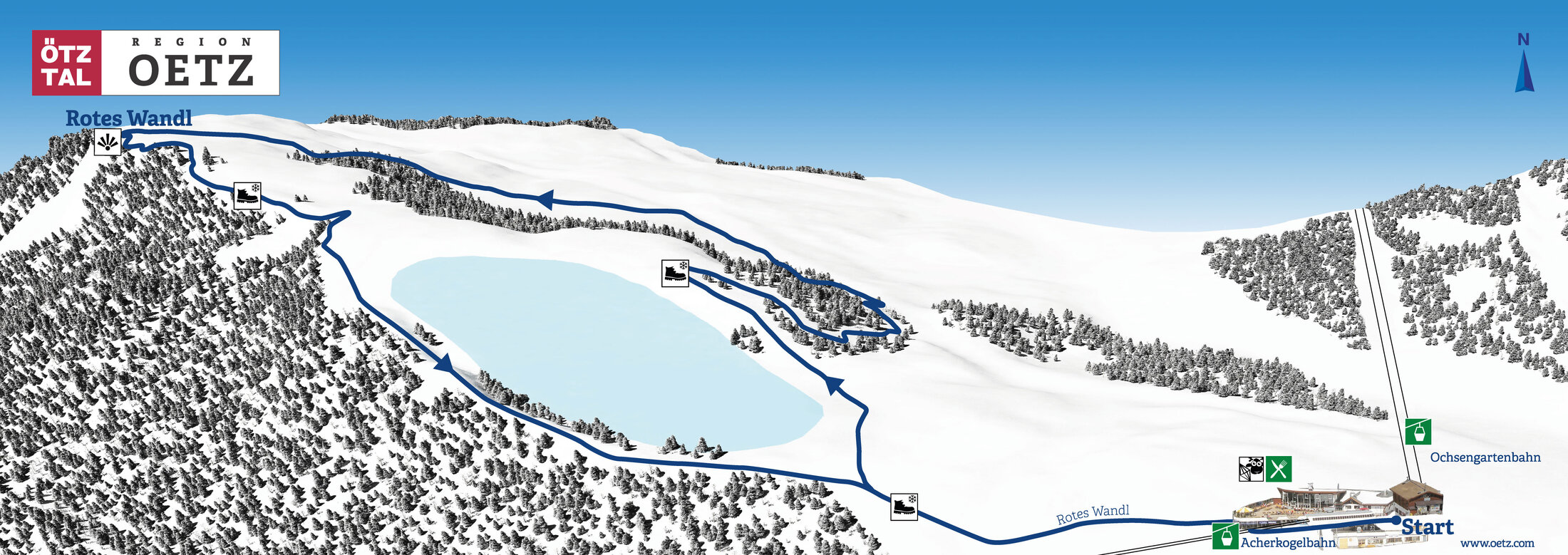
    Past the reservoir lake and the WIDIVERSUM, the route leads to the viewpoint "Rotes Wandl." From there, a beautiful view opens up over the front Ötztal and the Inn valley. The winter hiking trail is groomed and runs away from the ski slopes. The last ascent back to the reservoir lake is somewhat steeper. Only suitable for experienced winter hikers with good footwear. Tip: We recommend hiking/ski poles.

    Length: 1.4 km supervised panoramic circular route

    Duration: approx. 45 minutes

    Difficulty: easy/medium

    Start/entry: Panorama Restaurant Hochoetz

    Author’s recommendation

    A visit to WIDIs MOVIESHUTTLE is an absolute highlight for children!

    Profile picture of Ötztal Tourismus Büro Oetz
    Author
    Ötztal Tourismus Büro Oetz
    Logo Ötztal
    Responsible for this content
    Ötztal  Verified partner 
    Difficulty
    easy
    Overall difficulty
    easy

    Derived from the technical difficulty and the stamina requirements.

    Experience
    Landscape
    Highest point
    2,012 m
    Lowest point
    1,959 m
    Best time of year
    Jan
    Feb
    Mar
    Apr
    May
    Jun
    Jul
    Aug
    Sep
    Oct
    Nov
    Dec

    Track types

    Dirt road 81.72%Path 18.27%
    Dirt road
    1.2 km
    Path
    265 m
    Show elevation profile

    Rest stops

    Panoramarestaurant Hochoetz
    WIDIs Bistro
    Chrystal bar Hochoetz

    Safety information

    Please note the current snow and avalanche report for the coming days: https://www.oetztal.com/de/winter.html & https://avalanche.report/albina-web/bulletin/2019-01-07?lang=de

    Public transport

    Travel comfortably and safely by train to the Ötztal station. The final stop or exit point is ÖTZTAL station. Afterwards, you can travel conveniently and quickly by public transport or local taxi companies through the entire valley to your desired destination. The current bus schedule is available at: http://fahrplan.vvt.at

    Directions

    The car journey to ÖTZTAL. Located in Tyrol, the ÖTZTAL branches off to the south as the longest side valley of the Eastern Alps. Arrival by car takes travelers through the Inn valley up to the valley entrance and further along the Ötztal. In addition to the toll highway, country roads can also be used. Your drive can be quickly and conveniently determined using the route planner: To the route planner: https://www.google.at/maps

    Parking

    The following parking options are available:

    • Parking lot Acherkogelbahn (fee required)
    • Parking lot Rafting entry point (at the end of the village of Oetz on the right side) - free, but limited parking options, camping prohibited
    • Oetz town center parking (fee required)
    • Overnight parking during multi-day tours: Oetz town center parking; the ticket is available at the Oetz information office.
    • When taking the Ochsengarten gondola, free parking in Ochsengarten - camping prohibited

    Coordinates

    DD
    47.211916, 10.931865
    DMS
    47°12'42.9"N 10°55'54.7"E
    UTM
    32T 646287 5230524
    w3w 
    ///galleons.revolts.names
    Get there by train, car, bike, or on foot!

    Author’s map recommendations

    Kompass #043 | Ötztaler Alps Ötztal, Pitztal | 1:50,000

    Equipment

    Appropriate equipment such as breathable and weather-adapted outdoor clothing, wind, rain, snow and sun protection, a hat and gloves, is required for all hikes and routes. Carrying a first aid kit, a mobile phone, and possibly a route map, as well as sufficient provisions on routes without a place to rest, is necessary.


    Localization

    Parts of this content were machine translated using German as the source language

    Similar routes nearby

    • Map / Winterrunde Speicherteich- Nr. 432
      Winterrunde Speicherteich- Nr. 432
    • Winter hike Hochoetz - Kühtaile Alm
    • Winter route Ochsengarten - No. 420
    • Winter round Feldringalm (423)
    • Winter circuit Sautens - No. 401
     These suggestions were generated by our system
    Status
    closed
    Difficulty
    easy
    Overall difficulty
    easy

    Derived from the technical difficulty and the stamina requirements.

    Distance
    1.5 km
    Duration
    0:45 h
    Ascent
    52 m
    Descent
    53 m
    Highest point
    2,012 m
    Lowest point
    1,959 m
    Round trip Scenic Refreshment stops available Family-friendly Cableway ascent/descent Groomed snow

    Statistics

    • Content
    • Show images Hide images
    Features
    Maps and trails
    Nothing selected - click and drag in the elevation profile to zoom
    Distance
    Duration
    Ascent
    Descent
    Elevation profile