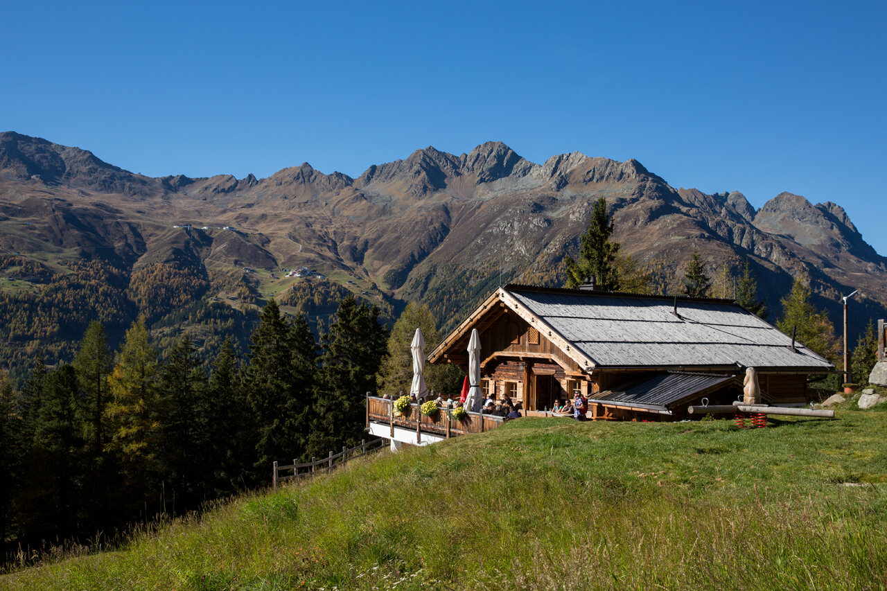
Hiking Trail

Stallwiesalm

Gemeinde Sölden
Top
Medium
Key facts
1:45 h Duration
2.98 km Length
465 m Ascent
2 m Descent
1,842 m Max. altitude
1,348 m Min. altitude
Stamina
Landscape
Quality of Experience
Best Season
Jan Feb Mar Apr May Jun Jul Aug Sep Oct Nov Dec

Description

SÖLDEN -> STALLWIESALM -> SÖLDEN

Map & elevation profile

SÖLDEN -> STALLWIESALM -> SÖLDEN
The Stallwiesalm is a popular alpine hut above Sölden, offering traditional Tyrolean cuisine, a sunny terrace, and a peaceful location. It can be reached by two different routes: a wide forest road or a shorter, steeper woodland trail.

Option 1: Via the Forest Road (easy & family-friendly)

The hike begins at the Freizeit Arena in the center of Sölden. From there, follow the Granbichlstraße uphill to the barrier near the edge of the forest. Here, a well-maintained forest road winds gently through a quiet wooded area. Along the way, you’ll enjoy beautiful views of the Ötztal valley. After about 1.5 hours, you reach the Stallwiesalm at 1,842 m, a cozy alpine hut perfect for a break.

Option 2: Via the Woodland Trail (shorter & steeper)

Also starting from the Freizeit Arena, a marked hiking trail branches off from the forest road shortly after the barrier. This steep forest path leads more directly up the mountain. It’s a shorter option – around 1 hour of walking time – but requires sturdy footwear and good footing, especially if the ground is wet.

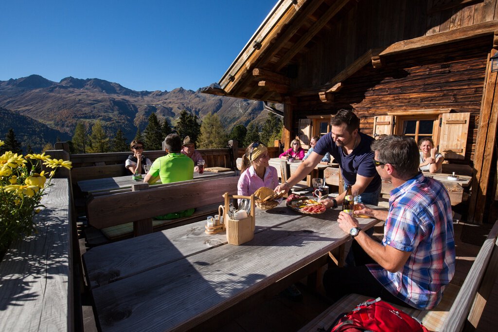
At 1,842 m, Stallwiesalm offers hearty local dishes, homemade desserts, and a relaxed mountain atmosphere. The hut is family-friendly, with outdoor seating and a small play area for children.

Author's tip
In summer bus transfer from Sölden to the Stallwies Alm.You can find the current timetable on the website of the Ötztaler Verkehrsgesellschaft

Regions & Places

Austria (Country)
Tyrol (Province)
Bezirk Imst (District)
Ötztal (Tourism area)
Sölden (Tourism area)
Gemeinde Sölden (Commune)

Mountain areas

Alps (Mountain area)
Stubai Alps (Mountain area)
Modified at 24.03.2026 · Created at 12.06.2013

Characteristics

Linear route
Scenic
Refreshment stops available
Family-friendly

Way types

Unbekannt 2.98 km

Safety guidelines

Moderate mountain trail; for sure-footed and experienced hikers. Good physical condition, mountain experience & mountain equipment (see notice equipment) necessary. Please pay attention to the current weather report:

Additional information

More details about hiking In Ötztal: https://www.oetztal.com/wandern 

Recommended literature

Almzeit

Recommended maps

Kompass #042 | Inneres Ötztal und Pitztal


From Sölden (Freizeit Arena), follow the forest road uphill for a gentle and family-friendly hike of about 1.5 hours to reach the cozy Stallwiesalm at 1,842 m.

Alternatively, take the steeper woodland trail shortly after the barrier for a shorter but more challenging ascent of about 1 hour.

The Stallwiesalm offers traditional Tyrolean food, a sunny terrace, and a relaxed mountain atmosphere—perfect for a break during your hike.

Public transit

Travel safe and comfortable with the train to the Ötztal Bahnhof train station. Last stop and exit point is the train station Ötztal Bahnhof. Afterwards you can travel smoothly and quick with the public transport or our local taxi companies through the valley to your desired destination. Please find the current bus timetable here:http://fahrplan.vvt.at


Starting point

Sölden

Getting there

The car drive to the Ötztal valley. Situated in Tirol, the Ötztal valley set off in southerly direction and is the longest side valley in the Eastern Alps. The journey with the car leads you through the Inntal valley to the entrance of the valley and further on through the valley. Among the toll motorways you can also use the countryroads. A route planner will show you the easiest and most convenient way: https://www.google.at/maps

Parking

The following parking facilities are available in Sölden:
  • Parking lot Postplatz
  • parking lot Stiegele
  • stair parking
  • Giggijochbahn + underground garage
  • Gaislachkoglbahn + underground garage
  • Parking Hochsölden
  • parking garage Hochsölden 1. parking lot

All parking is free during the day.

Parking for several days (eg hike tour):

  • Parkgarage Gaislachkoglbahn, Parkticket either online or directly at the cash desk of the Gaislachkoglbahn

Coordinates

11.010672, 46.96955
Plan arrival

The tour is within these protected areas.

Naturpark Ötztal (Protected area)
Ruhegebiet Stubaier Alpen (Protected area)

Appropriate equipment such as breathable suitable outdoor clothes for the weather, ankle-high walking boots, wind-, rain- & sun protection, hat, possibly gloves, is for all hikes and tours necessary. Please bring a first-aidbox, a mobile phone, a walking map and if there is no hut on the way a snack and enough to drink.