

Winter Hiking
Pestkapelle - Längenfeld 209
Längenfeld
Open
Top
Easy
Key facts
0:20 h
Duration
852 m
Length
31 m
Ascent
7 m
Descent
1,204 m
Max. altitude
1,167 m
Min. altitude
Best Season
Jan
Feb
Mar
Apr
May
Jun
Jul
Aug
Sep
Oct
Nov
Dec
Map & elevation profile
The Tour
SPORTZENTRUM LÄNGENFELD -> PESTKAPELLE LÄNGENFELD
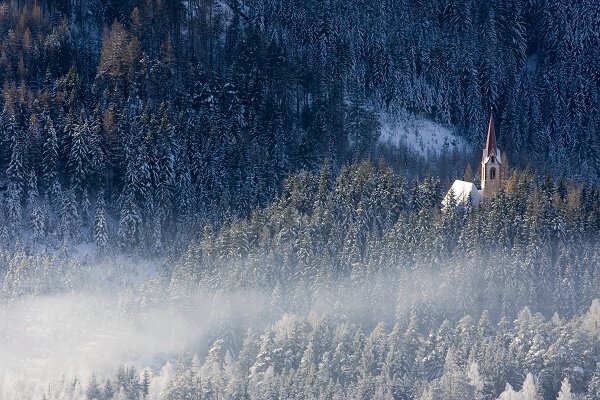
If you don‘t feel well then this is the right place, it provides a feeling of deep peace and quiet. A place that gives comfort to all those in need of encouragement. Just like the locals back in the 17th century who came here to mourn for the victims of the plague. It was a must to bury them on this shore of the river, therefore a small Trinity Chapel was erected in 1661 amid the forest at Kropfbühel area. Locals call the precious little building Bichl Church or Plague Chapel.
Closing your eyes you will feel the infinite strength coming from the red/white chapel. A place of silence where you refuel your energy.
Author's tip
Take your time and make a small detour and follow the path directly at the Fischbach. There you can see pictures by the artist Albin Egger (*1868 - †1926). These were created during his stays in Längenfeld.
Take your time and make a small detour and follow the path directly at the Fischbach. There you can see pictures by the artist Albin Egger (*1868 - †1926). These were created during his stays in Längenfeld.
Regions & Places
Austria (Country)
Tyrol (Province)
Bezirk Imst (District)
Ötztal (Tourism area)
Längenfeld (Commune)
Mountain areas
Alps (Mountain area)
Stubai Alps (Mountain area)
Ötztal Alps (Mountain area)
Modified at 02.12.2025 · Created at 03.11.2022
Details
Characteristics
Linear route
Cultural/historical interest
Way types
Safety guidelines
Please pay attention to the current weather- & avalanche report: https://www.oetztal.com/de/ & https://lawinen.report/bulletin/latest
The Ötztal Tourismus team will be happy to inform you personally about the nature of the winter hiking trails. Oetztal tourism T +43 5 72 00 300 - info@laengenfeld.com
Technical difficulty
Very easy - can be completed by anyone without specific technique training.
Additional information
More information about winter hiking can be found here:
https://www.oetztal.com/winter/the-full-winter-variety-in-oetztal/winter-hiking.html
Recommended maps
Map of Längenfeld
Directions
At the starting point of the hike, the Längenfeld sports center, you can already see the church tower of the plague chapel. The tour runs leisurely past the campsite into the small forest. You can already see the bridge that spans the Ötztaler Ache. After crossing this, it goes straight on and after a short climb you have already reached your destination.
Arrival
Public transit
Travel safe and comfortable with the train to the Ötztal Bahnhof train station. Last stop and exit point is the
train station Ötztal Bahnhof. Afterwards you can travel smoothly and quick with the public transport or our local
taxi companies through the valley to your desired destination. Please find the current bus timetable here:
http://fahrplan.vvt.at
Starting point
Sport Center Längenfeld
Getting there
The following parking options are available:
- Sports center Längenfeld
- Längenfeld town center (only a small number of parking spaces)
Parking
The following parking options are available:
- Sports center Längenfeld
- Längenfeld town center (only a small number of parking spaces)
Current information
Wednesday, 29.07.
Sun, clouds and warm, low risk of thunderstorms
Morning
18 °C
20%
Rainfall risk
Afternoon
32 °C
50%
Rainfall risk
Thursday, 30.07.
Lots of sunshine
Midsummer-like hot
Midsummer-like hot
Morning
17 °C
0%
Rainfall risk
Afternoon
34 °C
20%
Rainfall risk
Equipment
Appropriate equipment such as breathable suitable outdoor clothes for the weather, is for all hikes and tours necessary.