Mountain Hike recommended route

Hinterer Spiegelkogl

Mountain Hike · Gurgl
Logo Ötztal
Responsible for this content
Ötztal Verified partner 
  • Hinterer Spiegelkogel
    Hinterer Spiegelkogel
    Photo: Roland Grüner, Ötztal

Selected alternatives for you

    RAMOLHAUS -> HINTERER SPIEGELKOGL

    difficult
    Distance 10.9 km
    4:30 h
    535 m
    1,630 m
    3,426 m
    1,890 m

    From the Ramolhaus, follow a path northwards upward over the Ramolferner to the Ramoljoch, from there ascending over the Spiegelferner to the summit.

    Author’s recommendation

    Reservation of hut sleeping places necessary!

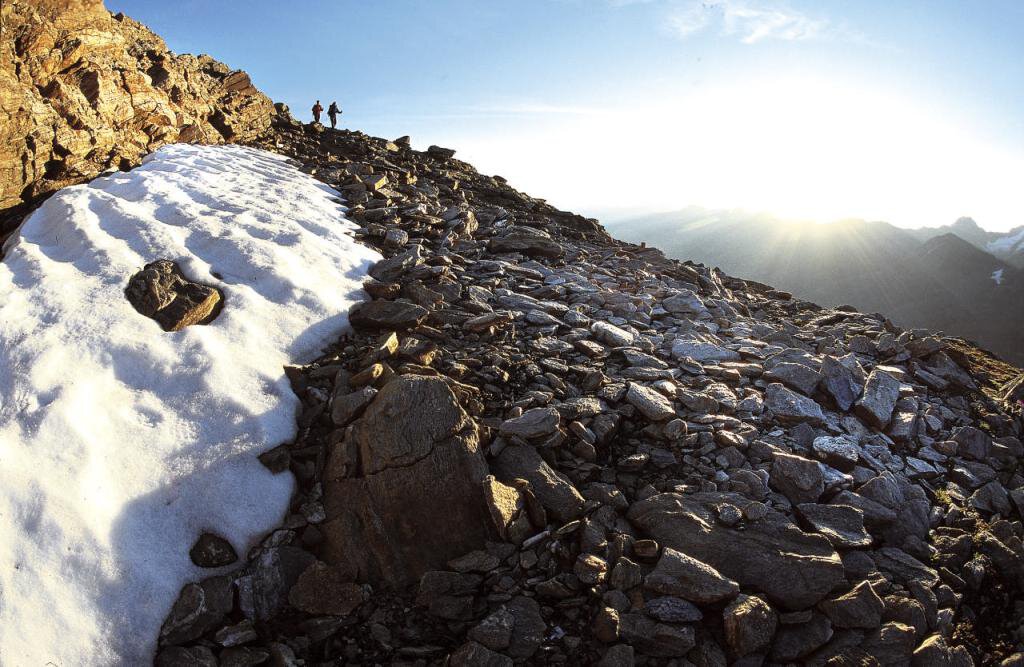
    The Hinterer Spiegelkog

    is only recommended for sure-footed and experienced mountaineers!

    Profile picture of Roland Grüner
    Author
    Roland Grüner 
    Logo Ötztal
    Responsible for this content
    Ötztal  Verified partner 
    Difficulty
    difficult
    Overall difficulty
    difficult

    Derived from the technical difficulty and the stamina requirements.

    Experience
    Landscape
    Highest point
    3,426 m
    Lowest point
    1,890 m
    Best time of year
    Jan
    Feb
    Mar
    Apr
    May
    Jun
    Jul
    Aug
    Sep
    Oct
    Nov
    Dec

    Track types

    Show elevation profile

    Safety information

    For those free from dizziness, sure-footed, and highly experienced in high alpine mountaineering; excellent physical condition, extensive mountain experience, alpine climbing equipment, securing and orientation devices, good weather conditions recommended. Please check the current weather report at: https://www.oetztal.com/de/sommer.html

    Tips and suggestions

    More info about hiking in the Ötztal: https://www.oetztal.com/wandern 

    Public transport

    Travel comfortably and safely by train to the Ötztal station. The final stop or exit point is the ÖTZTAL station. Afterwards, you can easily and quickly continue with public transport or local taxi services through the valley to your desired destination! The current bus timetable is available at: http://fahrplan.vvt.at

    Directions

    Car journey to the ÖTZTAL. Located in Tyrol, the Ötztal branches southward as the longest side valley of the Eastern Alps. Traveling by car leads visitors through the Inn Valley to the valley entrance and further along the Ötztal. Besides the toll highway, country roads can also be used. With the route planner, your drive can be quickly and comfortably determined: Route planner: https://www.google.at/maps

    Parking

    The following parking options are available in Obergurgl-Hochgurgl:

    • Village center parking lot Obergurgl (turn right down in front of the church, behind the multi-purpose building where the information office is located) parking meter with coin insertion
    • Parking lot at the village entrance – valley station Festkoglbahn, free – no overnight parking
    • Parking lot at the valley station of Hochgurglbahn, free – no overnight parking
    • Parking lot Top Mountain Crosspoint, free
    • Parking lot Hochgurgl, free (very small parking lot)

    In the mountaineering village Vent, the following parking options are available:

    • In summer in front of the village (parking meter, coins or EC card only) and at the valley station of the chairlift (at the mountain railways’ ticket office)

    Cost: €5.00 per day/car

    Coordinates

    DD
    46.829480, 10.969599
    DMS
    46°49'46.1"N 10°58'10.6"E
    UTM
    32T 650213 5188098
    w3w 
    ///fork.subdued.impairments
    Get there by train, car, bike, or on foot!

    Book recommendation by the author

    Ötztal Hiking Book | Helga Marberger | Publisher: Tyrolia

    Author’s map recommendations

    Kompass #042 | Inner Ötztal and Pitztal, Gurgler Tal, Venter Tal | 1:25,000

    Kompass #43 | Ötztal Alps, Ötztal, Pitztal | 1:50,000

    Freytag&Bernd WK 251 | Ötztal, Pitztal, Kaunertal, Wildspitze | 1:25,000

    Kompass | Bike & Hiking Map Ötztal | 1:35,000

    Equipment

    Appropriate equipment such as breathable and weather-appropriate outdoor clothing, ankle-high hiking boots, wind, rain and sun protection, a hat, and possibly gloves, is required for all hikes and routes. Carrying a first-aid kit, a mobile phone, and possibly a hiking map, as well as sufficient provisions for hikes without the option to stop for food, is necessary.

    Localization

    Parts of this content were machine translated using German as the source language

    Similar routes nearby

    • Bike & Hike Tour: Sölden - Gurgl - Langtalereck Hütte - Ramolhaus
    • Hochfirst - Obergurgl
    • Vent-Breslauer Hütte-Saykogel-Martin Busch Hütte-Kreuzspitze-Vent
    • Vent-Breslauer Hütte-Vernagthütte-Hochjoch Hospiz- Saykogel-Martin Busch Hütte-Kreuzspitze-Vent
    • Vent-Wilder Mann-Breslauer Hütte-Vernagthütte-Guslarspitze-Hochjoch Hospiz-Schöne Aussicht-Vent
     These suggestions were generated by our system
    Difficulty
    difficult
    Overall difficulty
    difficult

    Derived from the technical difficulty and the stamina requirements.

    Distance
    10.9 km
    Duration
    4:30 h
    Ascent
    535 m
    Descent
    1,630 m
    Highest point
    3,426 m
    Lowest point
    1,890 m
    Scenic Summit route

    Statistics

    • Content
    • Show images Hide images
    Features
    Maps and trails
    Nothing selected - click and drag in the elevation profile to zoom
    Distance
    Duration
    Ascent
    Descent
    Elevation profile