


Glacier Flea March - Obergurgl - Vent
Map & elevation profile
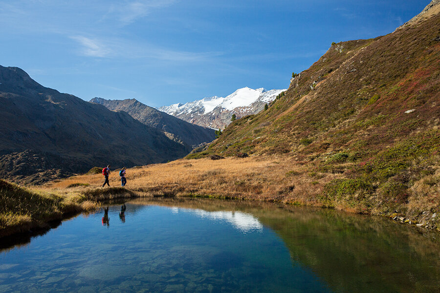
The Tour
The traditional march leads participants through the high alpine glacier world of the rear Ötztal up to the 3,200-meter-high Ramoljoch.
An event with views of the surrounding giant mountains of the Ötztal. Always on the first Sunday in August.
From Obergurgl over the Achbrücke initially somewhat steep to the "Beilstein", then over the Hochmähder to the Küppele shepherd's hut, further steeply upwards to the Ramolhaus and over the Ramol glacier and very rocky terrain in about 30 minutes to the entry of the Ramoljoch. There it is secured by rope, partly over ladders, to the Ramoljoch.
The descent leads over very rocky, steep terrain, then over an easier path to the Ramolalm (not managed!). From there descent to Vent. Only in good weather and with appropriate alpine equipment.
Surefootedness and fear of heights required!
Walking times:
Obergurgl - Ramolhaus: 3 - 4 h
Ramolhaus - Ramoljoch: approx. 1 h
Ramoljoch - Vent: 3.5 - 4 h
Important for all “Glacier Flea” participants
- that you only participate in the Glacier Flea March if you feel healthy and physically fit.
- that you do not leave the marked path.
- that you adopt a steady pace and can keep it up.
Regions & Places
Mountain areas
Details
Characteristics
Way types
Safety guidelines
Additional information
Recommended literature
Ötztal Hiking Book | Helga Marberger | Publisher: Tyrolia
Recommended maps
Kompass #042 | Inner Ötztal and Pitztal, Gurgler Valley, Venter Valley | 1:25,000
Kompass #43 | Ötztal Alps, Ötztal, Pitztal | 1:50,000
Freytag&Bernd WK 251 | Ötztal, Pitztal, Kaunertal, Wildspitze | 1:25,000
Kompass | Bike & Hiking Map Ötztal | 1:35,000
Directions
From Obergurgl over the Achbrücke initially somewhat steep to the "Beilstein", then over the Hochmähder to the Küppele shepherd's hut, further steeply upwards to the Ramolhaus and over the Ramol glacier and very rocky terrain in about 30 minutes to the entry of the Ramoljoch. There it is secured by rope, partly over ladders, to the Ramoljoch.
The descent leads over very rocky, steep terrain, then over an easier path to the Ramolalm (not managed!). From there descent to Vent. Only in good weather and with appropriate alpine equipment.
Surefootedness and fear of heights required!
Walking times:
Obergurgl - Ramolhaus: 3 - 4 h
Ramolhaus - Ramoljoch: approx. 1 h
Ramoljoch - Vent: 3.5 - 4 h
Arrival
Public transit
Travel comfortably and safely by train to the Ötztal train station. The final stop or exit point is ÖTZTAL station. Afterwards, travel conveniently and quickly by public transport or local taxi companies throughout the valley to your desired destination. The current bus schedule is available at: http://fahrplan.vvt.at
Starting point
Getting there
The car trip into the ÖTZTAL. Located in Tyrol, the Ötztal branches off to the south as the longest side valley of the Eastern Alps. Car travelers reach the valley via the Inn Valley up to the valley entrance and further along the Ötztal. Besides the toll highway, country roads can also be used. Your trip can be quickly and conveniently planned with the route planner: To the route planner: https://www.google.at/maps
Parking
- In summer in front of the village (parking meter, coins or EC card only) and at the valley station of the chairlift (at the ticket office of the cable cars)
Cost: €6.00 per day/car
The following parking options are available in Gurgl:
- Parking garage village center Obergurgl (go down right in front of the church), paid | € 2.00 first hour, for every additional 1/2 hour € 1.00 up until max. € 16.00 for 24 hours
- Parking garage village entrance – Festkoglbahn valley station, paid | € 6.00 from 8:00 am to 8:00 pm, € 10.00 from 8:00 pm to 8:00 am
- Parking lot Hochgurglbahn valley station, free – no overnight parking
- Parking lot Top Mountain Crosspoint, free
Current information
The tour is within these protected areas.
Equipment
Appropriate equipment such as breathable and weather-appropriate outdoor clothing, ankle-high hiking boots, wind, rain and sun protection, hat, possibly gloves, is required for all hikes and routes. Bringing a first aid kit, a mobile phone and possibly a hiking map, as well as sufficient provisions for hikes without refreshment possibilities, is necessary.